Tuesday, June 28, 2011

Google Earth Builder and the National Weather Service

In addition to being passionate about meteorology (and my wife of course), I am also passionate about geography and maps. Meteorology and geography are intertwined. Not much varies more over space and time than does weather. I feel more could be done in my organization, the National Weather Service, to serve our data internally and to the public through maps to help fulfill our mission of protecting life and property and enhance decision support. That's why the National Weather Service should be investigating "Google Earth Builder", coming out this fall.

ESRI
Before I get into Google Earth Builder, let me outline what the NWS (and geography professionals generally use) to make maps. A company named "ESRI" essentially has had a monopoly in the geospatial industry for very long now. If not a monopoly, a strong dominance. The software does a lot...pretty much all you could need. However, it has some definite drawbacks:

  • Very expensive for a license: many thousands of dollars.
  • Steep learning curve. Can be learned without a degree in geography or "GIS", but it's takes time, more time than most people have. 
  • Ultimately, the drawback with ESRI ends up being that only a handful of people are able to do the brunt of the geospatial work, and geospatial data is not served as well internally and externally as it could be.

Google Earth Builder
In contrast to ESRI/ArcGIS, Google Earth Builder appears easy enough that anybody can use it. Keep in mind that I only know what I know from webinars/presentations since it won't be released until the fall, but Google really wants to emphasize that it's easy to use, but offers more functionality than its existing geospatial products. Cloud storage is a big aspect of it. Google also wants to emphasize that this is targeting toward government organizations (hey, that's us!). And, by the way, there's a lot of interest in it, with 1200 people attending a webinar I was in a few weeks back. Some tidbits:

  • User interface will be a lot like pre-existing Google products such as Gmail, Google Docs, and Google Maps (a natural fit for the NWS since we are going to Google Apps later this year).
  • Because it's so Google oriented, it has a natural familiarity to both internal and external users. After all, who hasn't used Google maps? See screenshots at bottom.
  • Cloud data storage. Because the data is on the cloud, there's no cost for individual people to store the data, little or no duplication of storage (such as the same dataset being on 100 different workstations in an organization), and there's easy access to the data for different levels of users. 
  • Because GE Builder is browser/cloud based, nothing needs to be installed on your computer (unlike with ESRI/ArcGIS). Log into GE Builder and work from home!
  • Many different levels of users/permissions, set from an easy user interface. Google likes to term it "account editors, map editors, map users". No limit to the number of people who have access to the GE Builder account! Sharing is much easier. The sharing works a lot like Google Docs.
  • Although GE Builder doesn't have a single button to publish maps to the web, publishing to the web can still be automated pretty easily using APIs and such. But programming is generally not needed to use a vast majority of the GE Builder functionality.
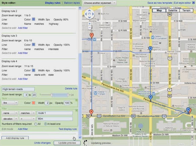
  • Dynamic styling of data. In other words, you can easily take the same dataset and show it different ways. (See the 2nd figure). Sure, Google Earth Pro has this functionality to a limited degree, but with GE Builder, this seems easier to do, yet with more styling/filtering capabilities. Although you can style data on the fly, obviously you can also save styles (stylesheets) for later use.
  • A lot of behind-the-scenes work is supposed to be done for you, like projecting data, image tiling, and more. (Hopefully, it'll finally allow for easy display of data which crosses 180 longitude.) With a lot of this behind-the-scenes work, GE Builder is supposed to be fast with large datasets.
  • Lots of analytics available.
  • Supposed to be easy to import existing shapefiles from ArcGIS. Although obviously Google is aiming for a cut of the ESRI market, they are emphasizing that they want it to be compatible with ArcGIS. This is smart because obviously few organizations would purchase GE Builder if they had to abandon all the geospatial work they had already done.
  • You still own the data, not Google.
The Data Management Interface. I love that thumbnails are available, so you don't waste time getting data that you know isn't what you're looking for. 

Dynamic Styling of your Geospatial Data

Links for More Information on Google Earth Builder
http://www.google.com/enterprise/earthmaps/builder.html
http://www.gearthblog.com/blog/archives/2011/04/more_about_the_google_earth_builder.html
https://www2.gotomeeting.com/register/523404994
http://www.spatiallyadjusted.com/2011/06/16/google-earth-builder-a-serious-geospatial-play-from-google/

Sunday, June 12, 2011

Directional Intelligence

Let me describe how I perceive direction. (I've been told I'm not normal.) I nearly always know which way is north, almost as if by instinct. I think of everything in terms of N/S/E/W, even when indoors. For example, at work, when going to bathroom, I know I'm headed slightly south of west. If I ever do get disoriented, I freak out and search for landmarks which I may know. But I try to keep this from happening. A situation which is more difficult for me is riding the subway in an unfamiliar city. When I exit the subway and get onto street level, I have to stop for a minute and get my bearings. I feel humiliated, almost freaked out. I've also gotten lost in New Mexico when hiking as a kid in dense fog. But these are exceptions, as I frequently venture off the beaten path and rarely get lost. Just ask people who have hiked with me...I know where I'm going.

If I freak out on the rare occasion I lose sense of which way is north, how do people who never know which way is north get by in life? I honestly cannot grasp this. My mother-in-law is one of those people who gets lost in Anchorage despite having the obvious navigational aid of the Chugach Mountains in the east. If she takes a route even slightly different from the route she's used to, she is hopelessly lost and may need to call me for help. Meanwhile, I actively explore new routes around town to get somewhere, not afraid that I'll get lost. And when hiking and cross country skiing, I love venturing off-trail, knowing that if I get a little disoriented, I'll probably be okay (even if I don't have GPS with me).

I often wonder if directional intelligence is something inherited or learned. I know that I was reading maps and guiding my parents around places as early as toddlerhood, which perhaps would suggest that at least some of it is inherited. But I don't think it's totally inherited. Directional intelligence comes with reading maps and knowing an area's landmarks, geography, and which was is north/south/east/west before trying to navigate in the area. Do I have a magnetic compass in my head? I don't think so. If I was blindfolded and placed in a new location on a cloudy day without any previous knowledge of the area's geography, I would be lost too. I believe through frequently reading maps and applying the maps to the real world, you can obtain directional intelligence. And no, just listening to your car's audible GPS directions, doesn't count!

Saturday, June 11, 2011

Backing into a Parking Space

In this blog post, I'm going to talk about an extremely important world issue...a matter of life and death...whether to back into or drive forward into a parking space. Sure, this is a seemingly trivial issue, but it is also quite polarizing. I admit it drives me a little bit bananas when I see a backed in car (I'm a forward parker). Probably I'm just jealous that the reverse parker has better parking skills than me. I admit, driving in reverse is not my specialty as it occupies less than 1% of my driving time. The one time I drive into a space in reverse is at the dump, and it absolutely terrifies me; I'm afraid I'm going to drive over the ledge where you dump your trash.

So the question arises, why do people back into parking spaces? It's not for ease. Although, when leaving, backing out of a parking space is more difficult than driving forward, backing in in the first place is way more difficult. In the unnatural reverse motion, when backing into a space, you're exiting an open area and going into a closed area. When leaving in reverse, you're exiting a closed area and entering an open area. If someone says overall it's easy to be a reverse parker, I don't buy it!

Another argument against backing into a parking space: society is habitually running late. When you're running late (which for most people is most of the time), why would you back into a space, wasting a precious 30 seconds? Maybe all reverse parkers are always running on time...I don't know. But I typically run on time and I'm not a reverse parker.

A reverse parker may give the safety argument. If you pull out of a parking space in reverse, you may hit a child or car you couldn't see. But couldn't you very easily scrape the car next to you when backing into the space in the first place? And when backing in, how do you keep yourself from pulling in too far and hitting something? This is not an easy task. And you could also hit a rogue child when backing into a space.

I think the most likely scenario is that the way we park depends not on any logical thought process, but on how our parents parked, and/or how we learned to park. We are more similar to our parents than many of us care to admit. For example, no matter how independent we think our thoughts may be, most of us have a similar political affiliation as our parents. Perhaps the way we park a car is no different.

Tuesday, June 7, 2011

New Girdwood Trail Map

I've been working on a new official Girdwood Trail Map for summer and winter, and am finally done! I did this map as part of my volunteer work with the Girdwood Trails Committee, which is part of Muni Parks and Rec. Below are the summer and winter maps. For a printable version of these maps with trail descriptions as well, see http://www.muni.org/Departments/parks/Documents/GWSummerTrlMap.pdf and http://www.muni.org/Departments/parks/Documents/GWWinterTrlMap.pdf


I did the map design and creation, although if it were only me, there are certain trails I would've added to the maps and certain ones I would've left off. It was certainly a team effort. Several of the more secret trails behind my house, for example, are not on this map. This is hopefully meant to be a map that a tourist could print (or pick up at a local store) and know where to hike (or cross country ski). The map also does not have all the Alyeska hiking/biking trails...only the major ones. Alyeska has a special map for the resort itself. BTW, note the new 5k nordic loop just north of the resort. This will open for the first time next winter, and is open for hiking this summer!

If you're in Girdwood and looking for a good hike, ask me for suggestions! My favorites for summer hiking (see summer map):

Easy
  • Virgin Creek Falls/Upper Virgin Creek Trail: Very short hike to one of the most beautiful little falls you'll ever see, especially in early summer when the snowmelt is still feeding it, or after a heavy late summer rain. Be sure to also go just past the falls and off to the right to see a pretty little gorge...just don't fall in! Also, check out my geocache "Alaskan Treasure" if you're into that.
  • Lower Virgin Creek Trail: Nice rainforest hike. Less crowded than the popular Winner Creek Trail. Heck, I've only seen someone else one it once! Can make a ~1.5 mile loop out of it by using a trail not on the map...ask me! Basically, take the Lower Virgin Creek Trail to where it Ts with another trail, and take this trail back, being sure to take the two right forks you'll see.
  • Winner Creek Trail to Hand Tram: This hike gets tons of people, but for good reason. Not for those seeking solitude.
Moderate
  • Upper Winner Creek Trail: Long ~8 one way/16 mile out and back on a well maintained trail (heading off this map) to a remote pass above treeline. Very gradual elevation gain, thus the moderate and not strenuous rating. Lush area, and be prepared for snow on the trail into early August. Great salmonberries in late summer/fall. Don't eat too much or you'll have too much of a tummy-ache on the way back! Probably don't want to do this hike if it's been really wet, as there are some stream crossings which I could see being difficult.
  • Iditarod NHT to the Hand Tram: About a mile down from a new parking lot on Crow Creek Rd to the Hand Tram. Some elevation change, but it's a good trail and a lot shorter to get to the hand tram than from the hotel, along with fewer people.
Strenuous
  • Max's Mountain: One of the best hikes in Alaska that nobody knows about (and not on this map). Start on the Upper Virgin Creek Trail, head left up the steep hill just after the falls, and then basically follow the ridgeline to treeline and to the top of Max's. Spectacular views all around and great blueberries in late summer at treeline. Trail is steep and somewhat indistinct, but it's hard to get lost and there are no exposed sections.
  • North Face Trail: Fantastic (now that it's actually done) trail up the North Face of Alyeska Resort. Only somewhat strenuous (about 2,000' elevation change over two miles). In a few years, once this gains attention and gets in the guidebooks, this will be one of Alaska's premier hikes, probably rivaling Bird Ridge and possibly Flattop. Ride the tram down for free, or take an alternate route down, making a loop.