ESRI
Before I get into Google Earth Builder, let me outline what the NWS (and geography professionals generally use) to make maps. A company named "ESRI" essentially has had a monopoly in the geospatial industry for very long now. If not a monopoly, a strong dominance. The software does a lot...pretty much all you could need. However, it has some definite drawbacks:
- Very expensive for a license: many thousands of dollars.
- Steep learning curve. Can be learned without a degree in geography or "GIS", but it's takes time, more time than most people have.
- Ultimately, the drawback with ESRI ends up being that only a handful of people are able to do the brunt of the geospatial work, and geospatial data is not served as well internally and externally as it could be.
Google Earth Builder
In contrast to ESRI/ArcGIS, Google Earth Builder appears easy enough that anybody can use it. Keep in mind that I only know what I know from webinars/presentations since it won't be released until the fall, but Google really wants to emphasize that it's easy to use, but offers more functionality than its existing geospatial products. Cloud storage is a big aspect of it. Google also wants to emphasize that this is targeting toward government organizations (hey, that's us!). And, by the way, there's a lot of interest in it, with 1200 people attending a webinar I was in a few weeks back. Some tidbits:
- User interface will be a lot like pre-existing Google products such as Gmail, Google Docs, and Google Maps (a natural fit for the NWS since we are going to Google Apps later this year).
- Because it's so Google oriented, it has a natural familiarity to both internal and external users. After all, who hasn't used Google maps? See screenshots at bottom.
- Cloud data storage. Because the data is on the cloud, there's no cost for individual people to store the data, little or no duplication of storage (such as the same dataset being on 100 different workstations in an organization), and there's easy access to the data for different levels of users.
- Because GE Builder is browser/cloud based, nothing needs to be installed on your computer (unlike with ESRI/ArcGIS). Log into GE Builder and work from home!
- Many different levels of users/permissions, set from an easy user interface. Google likes to term it "account editors, map editors, map users". No limit to the number of people who have access to the GE Builder account! Sharing is much easier. The sharing works a lot like Google Docs.
- Although GE Builder doesn't have a single button to publish maps to the web, publishing to the web can still be automated pretty easily using APIs and such. But programming is generally not needed to use a vast majority of the GE Builder functionality.
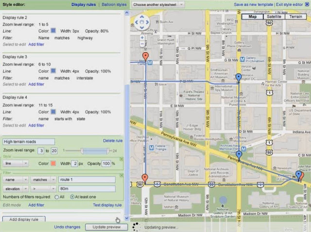
- Dynamic styling of data. In other words, you can easily take the same dataset and show it different ways. (See the 2nd figure). Sure, Google Earth Pro has this functionality to a limited degree, but with GE Builder, this seems easier to do, yet with more styling/filtering capabilities. Although you can style data on the fly, obviously you can also save styles (stylesheets) for later use.
- A lot of behind-the-scenes work is supposed to be done for you, like projecting data, image tiling, and more. (Hopefully, it'll finally allow for easy display of data which crosses 180 longitude.) With a lot of this behind-the-scenes work, GE Builder is supposed to be fast with large datasets.
- Lots of analytics available.
- Supposed to be easy to import existing shapefiles from ArcGIS. Although obviously Google is aiming for a cut of the ESRI market, they are emphasizing that they want it to be compatible with ArcGIS. This is smart because obviously few organizations would purchase GE Builder if they had to abandon all the geospatial work they had already done.
- You still own the data, not Google.
 |
| The Data Management Interface. I love that thumbnails are available, so you don't waste time getting data that you know isn't what you're looking for. |
 |
| Dynamic Styling of your Geospatial Data |
Links for More Information on Google Earth Builder
http://www.google.com/enterprise/earthmaps/builder.html
http://www.gearthblog.com/blog/archives/2011/04/more_about_the_google_earth_builder.html
https://www2.gotomeeting.com/register/523404994
http://www.spatiallyadjusted.com/2011/06/16/google-earth-builder-a-serious-geospatial-play-from-google/
No comments:
Post a Comment